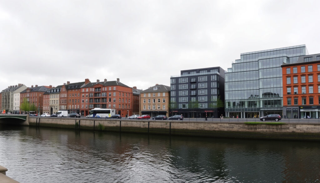
Sir John Rogerson’s Quay: History and Guide
Walking along the south bank of the River Liffey, you might notice how the old stone quays tell a story that modern office blocks can’t quite erase. Sir John Rogerson’s Quay — a half-mile stretch in Dublin 2 — has transformed from one of the 18th century’s most ambitious private quay projects into a commercial corridor, and this guide traces how the quay’s maritime past still shapes its character today.
Length: 0.5 miles (800 m) ·
Location: South bank of River Liffey, Dublin 2 ·
Named after: Sir John Rogerson (politician and property developer) ·
Construction era: 18th century ·
Postcode: D02 P3C6
Quick snapshot
- Built on reclaimed land using dredged Liffey material (Buildings of Ireland (National Inventory))
- Named for Sir John Rogerson, Lord Mayor of Dublin 1693-94 (Dublin City Film Office)
- Quay walls rebuilt in 1820s and again in 1869 (Buildings of Ireland (National Inventory))
- Some of the few remaining campshire warehouses in Dublin are here (Dublin City Film Office)
- Exact year of construction completion (Buildings of Ireland (National Inventory))
- Original name of the quay before its current naming (Buildings of Ireland (National Inventory))
- Full list of historical buildings now demolished (Buildings of Ireland (National Inventory))
- 1700s: construction and early maritime use
- 1800s: peak warehousing and shipping trade
- 1900s: decline of port activity
- 2000s: regeneration as commercial district
- Continued commercial office development
- Heritage preservation of campshire warehouses
- Improved pedestrian and cycling connections
Six key facts capture the quay’s scale and significance at a glance.
| Label | Value |
|---|---|
| Length | 0.5 miles (800 m) |
| Location | South bank of River Liffey, Dublin 2 |
| Named after | Sir John Rogerson (politician and property developer) |
| Postcode | D02 P3C6 |
| Construction era | 18th century |
| Coordinates | 53.3478° N, 6.2375° W |
What is the history of Sir John Rogerson’s Quay?
The quay is one of the few surviving examples of 18th-century private infrastructure in Dublin — a bet on trade that shaped the city’s south-east waterfront for three centuries.
18th-century development
- Sir John Rogerson’s Quay was laid out in the early 18th century as part of Dublin’s docklands expansion (Buildings of Ireland (National Inventory)).
- In 1713, Dublin Corporation leased 133 acres on the south bank of the Liffey to Sir John Rogerson on condition that he construct a quay (YouTube (historical documentary)).
- The quay was built as two parallel stone faces with the space between filled with material dredged from the River Liffey (Buildings of Ireland (National Inventory)).
- The development is described as the most ambitious privately funded quay project of its period (Buildings of Ireland (National Inventory)).
Brooking’s map of 1728 shows the quay lined with gable-fronted buildings and land behind it still inundated by tides (Buildings of Ireland (National Inventory)). By the time of Rocque’s map in 1756, a more varied mix of buildings and yards associated with maritime trades had appeared (Buildings of Ireland (National Inventory)).
The quay reached completion at the end of the 18th century, followed by residential development on streets laid out to its south (Buildings of Ireland (National Inventory)).
19th-century warehousing
- The quay walls were rebuilt in the 1820s and again in 1869 as part of channel deepening on the River Liffey (Buildings of Ireland (National Inventory)).
- The warehouse at 30-32 Sir John Rogerson’s Quay was built in the 1890s, serving the growing import-export trade (Come Here To Me (Dublin history blog)).
- Campshire warehouses — a distinctive Dublin architectural type with red brick and stone dressings — lined the quay, and some of the few remaining examples survive today (Dublin City Film Office).
20th-century decline
- As shipping moved downstream to deeper berths, the quay’s port activity declined steadily through the 20th century (Dublin Port Company (port authority)).
- A diving bell, in constant use on the quay until 1958 for underwater maintenance, was placed on display in 2000 as part of a community project (Dublin City Film Office).
- In 2014, Dublin Port created a more permanent display by raising the diving bell and building a small museum underneath (Dublin City Film Office).
21st-century regeneration
- Large-scale office developments replaced derelict warehouses from the early 2000s, including the IPUT property at 33-34 Sir John Rogerson’s Quay (IPUT (commercial property investor)).
- Reynaers completed a facade refurbishment at the quay, applying modern glazing systems to historic structures (Reynaers (architectural systems)).
- The quay is now part of the Dublin Docklands Strategic Development Zone, zoned for mixed-use commercial and residential development (Dublin City Council (planning authority)).
The pattern: each era left its mark on the quay’s fabric, and the tension between preservation and development continues to define its character.
Where is Sir John Rogerson’s Quay located?
Positioned between City Quay and Britain Quay, the quay forms the southern edge of Dublin’s historic port — a half-mile corridor that connects the city centre to the Docklands’ modern glass-and-steel district.
Coordinates and map
- The quay lies at approximately 53.3478° N, 6.2375° W.
- Sir John Rogerson’s Quay runs from Creighton Street toward Ringsend and turns at a right angle at the River Dodder (Buildings of Ireland (National Inventory)).
- Google Maps and Waze both index the quay as “Sir John Rogerson’s Quay, Dublin 2.”
Boundaries: City Quay to Britain Quay
- The quay forms the south bank of the Liffey between City Quay to the west and Britain Quay to the east (Wikipedia (Dublin geography)).
- It is bordered on the north by the River Liffey and on the south by streets like Cardiff Lane and Misery Hill.
- The Sean O’Casey Bridge, a pedestrian footbridge opened in 2005, connects the quay to North Wall Quay on the opposite bank (Dublin City Council (bridge information)).
Proximity to Sean O’Casey Bridge
- The bridge provides a 130-metre crossing for pedestrians and cyclists, linking Sir John Rogerson’s Quay directly to the 3Arena and the Point Village (Dublin City Council (bridge information)).
- Walking from the quay to O’Connell Bridge takes approximately 20 minutes along the Liffey boardwalk.
The implication: Sir John Rogerson’s Quay sits at the hinge point between Dublin’s historic city centre and its modern Docklands — a location that explains both its 18th-century maritime importance and its 21st-century regeneration appeal.
What are the names of the quays in Dublin?
Fifteen quays line the River Liffey between the Phoenix Park and Dublin Port; understanding their arrangement helps place Sir John Rogerson’s Quay in context.
North bank quays
- From west to east: Wolfe Tone Quay, Sarsfield Quay, Ellis Quay, Arran Quay, Inns Quay, Ormond Quay Upper, Ormond Quay Lower, Eden Quay, Custom House Quay, North Wall Quay, Alexandra Basin Way.
- North bank quays historically handled passenger traffic and general cargo (Wikipedia (Quays of Dublin)).
South bank quays
- From west to east: Victoria Quay, Usher’s Island, Usher’s Quay, Merchants Quay, Wood Quay, Essex Quay, Wellington Quay, Crampton Quay, Aston Quay, Burgh Quay, George’s Quay, City Quay, Sir John Rogerson’s Quay, Britain Quay, Hanover Quay (Wikipedia (Quays of Dublin)).
- South bank quays were traditionally deeper and handled heavier maritime trade, including the Dublin Port operations that centred on Sir John Rogerson’s Quay in the 18th and 19th centuries.
Notable quays: Eden, Merchants, Sir John Rogerson’s
- Eden Quay, on the north bank, was built in the 18th century and is now a transport hub with Busáras station (Wikipedia (Eden Quay)).
- Merchants Quay, on the south bank, housed the city’s medieval merchants and is now near Christ Church Cathedral (Wikipedia (Merchants Quay)).
- Sir John Rogerson’s Quay is the longest of the south bank quays dedicated to industrial and commercial use, stretching 0.5 miles.
The pattern: each quay reflects its era — medieval (Merchants), Georgian (Eden, Sir John Rogerson’s), and modern (North Wall, Britain). Sir John Rogerson’s sits at a rare intersection of all three.
What does quay mean in Ireland?
Unlike “quay” in British English, which often implies a purely functional wharf, the Irish “quay” carries a dual meaning — it is simultaneously a working waterfront and a named street address, sometimes centuries old.
Etymology of quay
- The word “quay” derives from Old French “kai,” meaning a stone landing place for ships (Online Etymology Dictionary).
- In Irish geography, “quay” is used interchangeably with “wharf” but more commonly denotes a street or road running alongside a river or dock.
- Unlike the US usage of “pier,” Irish quays are almost always solid stone or concrete structures parallel to the shoreline, not jutting out.
Usage in Irish geography
- The term “quay” appears in the official addresses of thousands of buildings in Dublin, Cork, Limerick, Waterford, and Galway (Logainm (Irish Placenames Commission)).
- Sir John Rogerson’s Quay is officially classified as both a quay (for infrastructure) and a street (for postal addressing) — a dual identity common in Irish urban geography.
- Irish postal addresses use “Quay” as part of the street name, not as a suffix: e.g., “Sir John Rogerson’s Quay, Dublin 2,” not “Sir John Rogerson’s Street.”
Difference between quay and street
- In Dublin, a “quay” is always adjacent to water and usually pre-dates surrounding streets (Ask About Ireland (Irish geography resource)).
- A “street” may be inland; quays by definition run along a river or canal.
- Sir John Rogerson’s Quay is representative: the quay itself was built first, and the residential streets to its south (like Cardiff Lane) were laid out later.
How to get to Sir John Rogerson’s Quay?
Public transport access is strongest from the east (Docklands) and west (city centre), but the quay sits in a gap between Luas lines — a 10-minute walk in either direction is inevitable.
By bus
- Dublin Bus routes 76, 79, and 151 serve the quay directly, with stops near the intersection with Cardiff Lane (Dublin Bus (transport authority)).
- Route 76 runs from Tallaght to the Docklands; route 79 operates between Ballymun and Merrion.
- Route 151 connects Dunboyne to the Docklands, stopping at Sir John Rogerson’s Quay (Dublin Bus timetable data).
- Additional bus services from nearby stops on Pearse Street include routes 2, 3, 11, 14, 27, 27A, 33, 41, 41C, 44, 47, 61, 84, 84A, 116, 142, and 145.
By Luas
- The nearest Luas stop on the Red Line is The Point, approximately a 10-minute walk east along the quay (Luas (Dublin light rail operator)).
- Busáras stop, on both the Red and Green lines via the future cross-city link, is about a 12-minute walk west across the Sean O’Casey Bridge.
- Bord Gáis Energy Theatre, a five-minute walk east, marks the boundary between Sir John Rogerson’s Quay and Britain Quay.
By car
- Street parking is limited; the nearest public car parks are at the CHQ Building (200 spaces) and the Q-Park at Grand Canal Square (450 spaces) (Q-Park (car park operator)).
- The quay is within Dublin’s toll zone for the Port Tunnel; drivers heading from the M50 southbound should exit at junction 3 for the East Wall Road direction.
- Cycle parking is available outside most office buildings on the quay; Dublin Bikes stations are located at Cardiff Lane and Grand Canal Square.
Walking from city centre
- From O’Connell Street, walk south-east via O’Connell Bridge, turn right along Burgh Quay, and follow the Liffey boardwalk for approximately 20 minutes (Visit Dublin (tourist authority)).
- From Pearse Street Station, a 10-minute walk south along Pearse Street then east along Misery Hill brings you to the quay’s western end.
- The Sean O’Casey Bridge, accessible from the IFSC (North Wall Quay), provides a direct pedestrian crossing to the quay’s midpoint.
Timeline: Sir John Rogerson’s Quay through the centuries
What we know for certain
- The quay was built in the 18th century on reclaimed land using dredged Liffey material.
- Sir John Rogerson was Lord Mayor of Dublin (1693-94) and the quay’s namesake.
- The quay is 0.5 miles long and lies on the south bank of the Liffey in Dublin 2.
- Quay walls were rebuilt in the 1820s and 1869.
- Some of Dublin’s last remaining campshire warehouses are here.
- A diving bell used until 1958 is now on permanent display.
- Modern office buildings replaced warehouses from the early 2000s.
What is unclear
- The exact year construction finished is not recorded.
- The name predates the quay’s official records — its original designation is unknown.
- No full inventory exists of which historical buildings were demolished during 20th-century decline.
- The precise boundary between Sir John Rogerson’s Quay and Britain Quay varies by source.
What people are saying about Sir John Rogerson’s Quay
“Sir John Rogerson’s Quay is a street and quay in Dublin on the south bank of the River Liffey between City Quay in the west and Britain Quay.”
Wikipedia (community-edited encyclopedia)
“The quay runs for exactly half a mile along the southern banks of the River Liffey.”
For anyone walking Sir John Rogerson’s Quay, the physical evidence of all three centuries coexists: stone quay walls from the 1869 rebuild, a campshire warehouse as a living museum of port-era architecture, and glass office facades that signal the Docklands’ 21st-century identity. The quay has never been purely one thing — and that layered history is exactly what makes it worth understanding, whether you’re an investor, a historian, or just someone crossing the Sean O’Casey Bridge on a Tuesday morning.
comeheretome.com, evendo.com, en.wikipedia.org, archiseek.com, iput.com, historyireland.com, engineersireland.ie, m.joyceproject.com
For a more detailed history of Sir John Rogerson’s Quay, see detailed history of Sir John Rogersons Quay.
Frequently asked questions
What is Sir John Rogerson’s Quay?
Sir John Rogerson’s Quay is a street and quay on the south bank of the River Liffey in Dublin 2, built in the 18th century and named after Sir John Rogerson, a politician and property developer who served as Lord Mayor of Dublin.
How long is Sir John Rogerson’s Quay?
The quay is half a mile long (approximately 800 metres), running between City Quay and Britain Quay.
Who was Sir John Rogerson?
Sir John Rogerson was a politician and property developer who served as Lord Mayor of Dublin from 1693 to 1694. In 1713, Dublin Corporation leased him 133 acres on the south bank of the Liffey on condition he construct a quay (YouTube (historical documentary)).
What buildings are on Sir John Rogerson’s Quay?
The quay features a mix of modern office blocks (including the IPUT property at 33-34), surviving campshire warehouses from the 1890s, and the diving bell museum at the western end. Notable facade work by Reynaers has updated some historic structures (Reynaers (architectural systems provider)).
Is Sir John Rogerson’s Quay in Dublin 2?
Yes, the quay is located in Dublin 2, with the postcode D02 P3C6.
How to get to Sir John Rogerson’s Quay by bus?
Dublin Bus routes 76, 79, and 151 serve the quay directly. Additional services from nearby Pearse Street include routes 2, 3, 11, 14, 27, 33, 41, 44, 47, 84, 116, and 145 (Dublin Bus (transport authority)).
What is the nearest Luas stop to Sir John Rogerson’s Quay?
The nearest Luas stop is The Point (Red Line), approximately a 10-minute walk east. Busáras stop is about 12 minutes west across the Sean O’Casey Bridge (Luas (Dublin light rail operator)).
Are there parking facilities at Sir John Rogerson’s Quay?
Street parking is limited. The nearest public car parks are the CHQ Building (200 spaces) and Q-Park Grand Canal Square (450 spaces) (Q-Park (car park operator)).
More related posts
 Scent of a Woman: Cast, Oscar Win & Famous Line
 Sugar Rush 1000 Demo: Play Free with x1024 Multipliers
 Ted Lasso Season 4: New Direction, Cast, and Premiere Date
 1 Euro in INR Today: Live Rate, Trends & Comparisons
 Smart Home Device Security Risk: Vulnerabilities & Fixes
 Best Chinese Takeaway Near Me: Dublin Picks & Healthier Orders
 Best Hotels in Dublin City Centre: Top Picks & Guides
 Jack & Jones Jeans: Are They Luxury? Fit, Origin & Top Brands
